Crazy about the Greek island of Crete!
E4 Hiking Trail Crete
Table of Contents
Introduction to the E4 Hiking Trail Crete
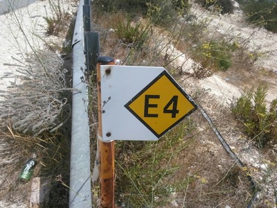
The E4 Hiking Trail Crete offers lots of walking holiday opportunities on the Greek Island of Crete, from gentle walks to very challenging hiking routes.
For those who like hiking, trekking, biking and walking and are up for a challenge then maybe the E4 European Long Distance Path, or at least part of it, will be right for you. If you want to hike the whole E4 trail allow yourself 3 - 4 weeks.
Although we've not walked the whole distance of the E4 Path in Crete, we have completed sections of it.
Overview of the Crete E4 Path

The E4 Hiking Trail Crete, or the European Long Distance Path, actually begins in Spain and continues through France, Switzerland, Germany, Austria, Hungary, Romania, Bulgaria, Greece (including the length of Crete) and ends in Cyprus.
The
whole E4 path is over 10,000 km long and was developed by the European
Ramblers Association (ERA), which covers 55 rambler’s associations
across Europe and was founded in 1969.
In Crete and throughout
Greece the E4 path was founded and is maintained by the Hellenic
Federation of Mountaineering and Climbing.
There is one large trekking or hiking route on the Greek Island of Crete, which is part of the E4 European Long Distance Path. The E4 trail covers the White Mountains (Lefki Ori), Mount Psiloritis (Mount Ida) and the Mount Dikti. The E4 Path is 320 km long.
The Crete leg of the E4 Hiking Trail Crete begins at Kastelli Kissamos in the west of Crete and crosses along the whole Island reaching Kato Zakros in the east where it ends. In Crete the E4 path is signposted by yellow markers and yellow and black arrows.
You will need a good map of Crete if you want to take on walking the E4 European Path in Crete. You will also need to note that in Crete and the whole of Greece you may be a little confused by some of the different spellings of the village, town and place names you may come across on maps or road signs.
For example, for the capital of Crete, Heraklion, you may see it as Heraklio, Irakleion, Iraklion or Iraklio.
Chania, the former capital, can be spelt as Hania or sometimes Xania.
Quite regularly you’ll find the letter ‘G’ as an alternative to the letter ‘Y’ as in Agios Nikolaos or Ayios Nikolaos. Sometimes added to this is the letter 'H' making it Aghios Nikolaos! And very commonly words with one ‘S’ can be seen with two, as in Lasithi or Lassithi.
It's a good idea to ask the locals if you are unsure!
Key Sections of the E4 Hiking Trail Crete
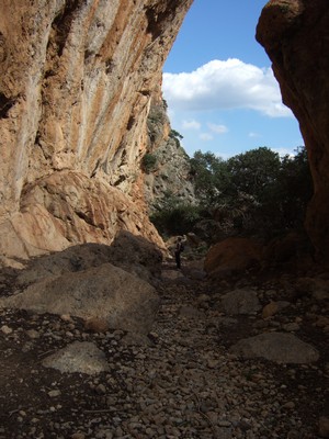
The E4 Path route is quite varied and can range from what amounts to simple walking on smooth asphalt roads to some hefty hiking in rugged gorges, right up to some real mountain trekking.
In parts the E4 trail is very overgrown, difficult to follow, and often not marked at all.
At Sougia, a small resort on the south coast, the E4 Path forks into two
tracks, one along the coast, which is very rough, and one through the
mountains. The tracks converge on the south coast near Frangokastello,
but immediately branch out again into two sections.
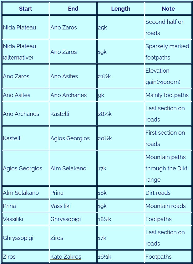
The following tables contain lists of the different sections of the E4 European Long Distance Path in Crete.
Common Western Stages
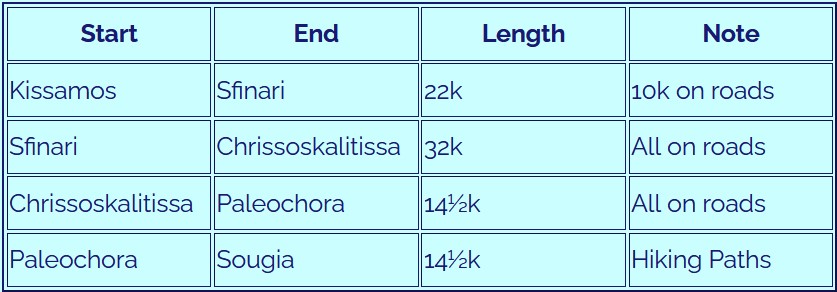
Coastal Stages
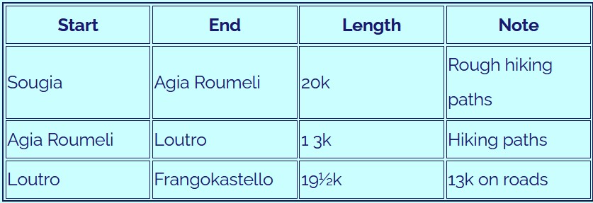
Alpine Branch
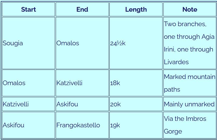
Northern Branch
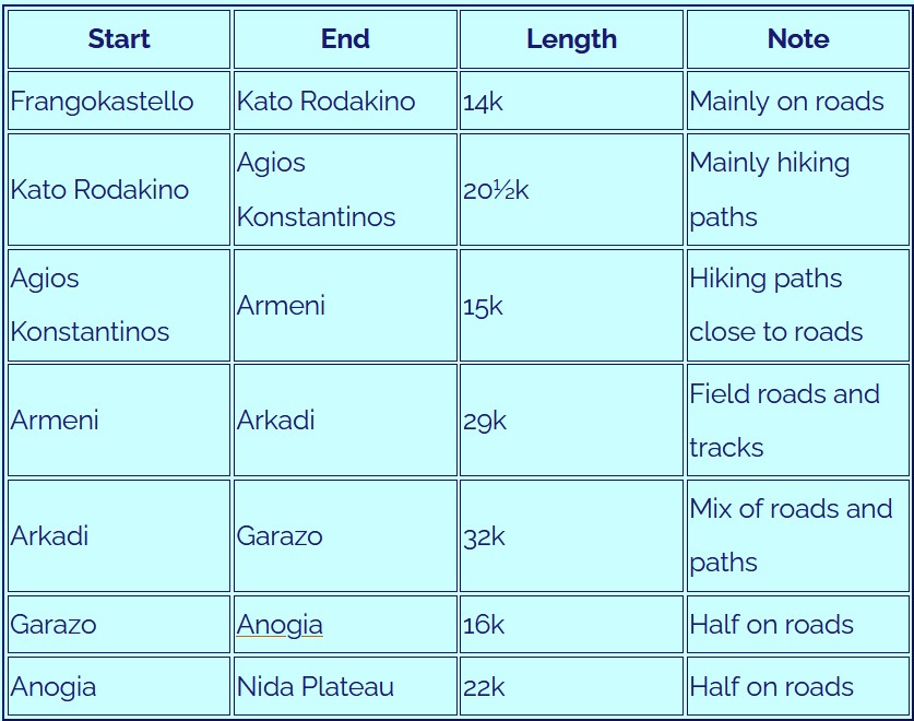
Common Eastern Stages
Mountain Refuge Huts
Hikers and trekkers embarking upon the E4 trail need to think about pre-planning their accommodation. This applies in particular to the alpine leg of the E4 Path, when any proposed stay at a mountain refuge hut needs to be prearranged.
The mountaineering clubs of Chania, Rethymnon, Heraklion and Lassithi maintain the following huts:

Why the E4 Trail in Crete Stands Out
Discover serene beaches perfect for unwinding after conquering the E4 trail in Crete. Visit the Best Beaches page.
The E4 Hiking Trail in Crete isn’t just a path—it’s an adventure through time, nature, and some of the most stunning landscapes Greece has to offer. From rugged mountains to pristine beaches, this trail promises an unforgettable journey for every type of walker, whether you're a seasoned trekker or just testing out your hiking boots.
A Trail That Has It All
The E4 Trail in Crete is like the ultimate sampler platter for nature lovers. Here's why it stands out:
- Diverse Landscapes: One moment you’re scaling the majestic White Mountains, and the next, you’re strolling along golden sand beaches. Few trails offer such an incredible variety of scenery in one stretch.
- Rich History: As you walk, you’ll pass ancient ruins, Byzantine churches, and quaint villages where time seems to have stood still. It’s like hiking through Crete’s history book.
- Perfect for All Levels: Wondering about the best sections of the E4 hiking trail in Crete? Beginners can stick to shorter, easier segments like the coastal routes, while pros might tackle the rugged highlands. There’s truly something for everyone.
If it’s breathtaking views you’re after, the scenic routes on the Crete E4 path won’t disappoint. Highlights include:
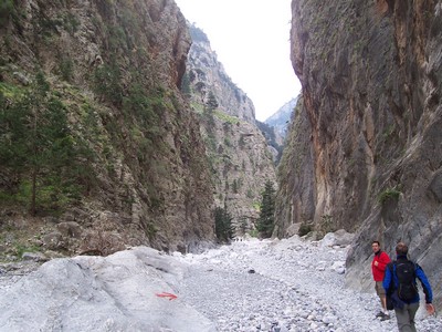
- Samaria Gorge: One of the most iconic stretches, this gorge combines towering cliffs with crystal-clear streams.
- Loutro to Chora Sfakion: A dreamy coastal route where the turquoise waters of the Libyan Sea will tempt you to take a dip.
- Omalos Plateau: Sweeping views of the White Mountains, dotted with wildflowers in spring.
“Walking the E4 in Crete felt like stepping into a postcard—every turn brought a new jaw-dropping view!” – A happy hiker.
A Few Fun Facts
- How long is the E4 trail in Crete? The trail stretches an impressive 320 kilometers, running from the eastern tip of the island at Kato Zakros to the westernmost point at Elafonisi.
- Planning a hike on the E4 trail Crete? You don’t have to tackle it all at once. Most hikers prefer to break it into sections over several days (or weeks!)
E4 Crete Trail Tips for Beginners
Before lacing up your boots, keep these essential tips for beginners and seasoned hikers in mind:
- Packing Essentials: A solid pair of hiking shoes, a hat, sunscreen, and plenty of water are non-negotiable. For overnight stays, pack light but include a first aid kit and snacks.
- Seasonal Advice for Hiking E4 Crete: Spring and autumn are the best times to hike. Summers can be scorching, while winters may bring rain or even snow in the higher elevations.
- Accommodation Near the E4 Hiking Trail: Many villages along the route offer charming guesthouses or traditional inns. Loutro, Anogia, and Chora Sfakion are great spots to rest and recharge.
“The E4 is more than a hike—it’s a way to connect with Crete’s raw beauty and welcoming people.”
Safety First
Hiking the E4 trail is incredibly rewarding, but it’s essential to stay safe.
- Always check the weather before setting out.
- Let someone know your route and expected return time.
- Stick to marked paths to avoid getting lost.
- Carry a fully charged phone or GPS device.
The E4 Hiking Trail in Crete isn’t just a physical journey—it’s a soulful one. You’ll leave with more than just beautiful photos; you’ll carry memories of sunlit gorges, friendly locals, and the sheer joy of walking through one of the most diverse and stunning places in the world. Whether you’re in it for the challenge or the views, this trail will leave you inspired.
Best Time to Hike the E4 Trail in Crete
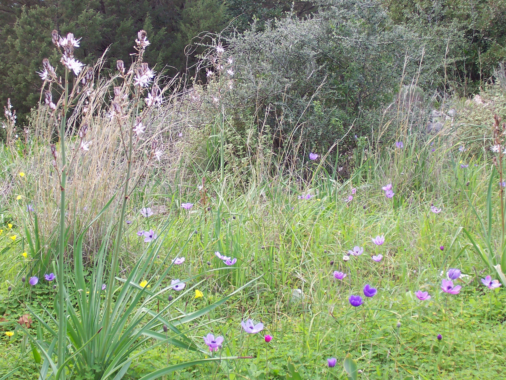
Timing is everything when it comes to the E4 Hiking Trail Crete, and picking the right season can make or break your adventure. Here’s when the trail truly shines:
Spring: A Blooming Wonderland
From March to May, the trail is a hiker’s paradise. Wildflowers blanket the hills, and the weather is pleasantly mild. It’s also a great time for spotting wildlife and enjoying the scenic routes on the Crete E4 path without the summer heat.
Autumn: Golden and Glorious
September to early November offers cooler days and fewer crowds. The countryside takes on a warm, golden hue, and the sea is still inviting for post-hike swims. Plus, villages along the way feel quieter but just as welcoming.
Summer: Only for the Brave
Hiking in July and August is doable but challenging due to the heat. Early starts and shaded routes are essential - and bring plenty of water!
Winter: A Different Perspective
While winter hikes (December to February) are possible in lower altitudes, higher sections of the trail, like the White Mountains, may be snowy or inaccessible. Stick to coastal paths for safer journeys and heed all hiking safety tips for the E4 trail in Crete.
Quick Tips for Choosing Your Season
- Spring and autumn are the most comfortable and scenic.
- Avoid midday hikes in summer unless you like feeling like a grilled souvlaki.
- Always check local weather forecasts before heading out.
Choose the season that suits your style, and the E4 trail will reward you with stunning landscapes, unforgettable experiences, and a hike to remember!
Must-See Landmarks Along the E4 Path
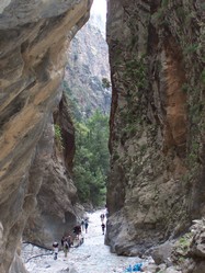
The E4 Hiking Trail Crete isn’t just a route through nature—it’s a journey through the island’s history, culture, and stunning landscapes. Here are the must-see landmarks that make this trail truly unforgettable:
1. Samaria Gorge
Known as one of the best sections of the E4 hiking trail in Crete, the Samaria Gorge offers towering cliffs, cool streams, and a trek through Europe’s longest gorge. It’s a challenging stretch but worth every step for the jaw-dropping views.
2. Agia Roumeli
This charming coastal village greets you after exiting the Samaria Gorge. It’s a perfect spot to rest, refuel, and dip your toes in the Libyan Sea. Plus, it’s one of the most scenic stops on the Crete E4 path.
3. Omalos Plateau
Nestled in the White Mountains, this plateau is a serene landscape surrounded by peaks and dotted with traditional shepherd huts. It’s a must-visit for those planning to explore higher altitudes of the trail.
4. Loutro
Accessible only by foot or boat, this picturesque village offers a tranquil retreat along the trail. Crystal-clear waters and whitewashed buildings make it feel like a hidden gem.
5. Kato Zakros
At the eastern end of the trail, you’ll find the ancient ruins of the Minoan Palace of Zakros. This archaeological site is steeped in history and provides a fascinating end to your hike.
Preparing for the E4 Hiking Trail Crete Adventure

Getting ready for the E4 Hiking Trail Crete is almost as exciting as the hike itself! A little planning and preparation go a long way toward making your trek enjoyable and safe. Whether you're a beginner or a seasoned hiker, here are some tips to keep you trail-ready.
Plan Your Route Wisely
The E4 trail offers something for everyone, from coastal strolls to rugged mountain climbs. Decide which sections match your fitness level and interests. Beginners might enjoy the gentler coastal paths, while more experienced hikers can explore the high-altitude White Mountains.Pack Smart,
Pack Light
- the E4 trail in Crete spans 320 kilometers, so splitting it into manageable sections is key.
- Look into seasonal advice for hiking E4 Crete to determine the best time for your adventure.
A well-packed bag can make all the difference. Essentials for the trail include:
- Sturdy hiking boots with good grip
- Lightweight clothing suited to the season
- A hat, sunscreen, and sunglasses for sunny days
- Plenty of water and snacks
- A first aid kit and a fully charged phone
Stay Safe and Informed
The trail is breathtaking, but it also has its challenges. Keep these safety tips in mind and plan your stops.
- Check the weather before setting out, especially if tackling the mountain routes.
- Stick to marked paths and use maps or GPS to avoid getting lost.
- Follow hiking safety tips for the E4 trail in Crete, especially if traveling solo.
Accommodation options near the trail range from cozy guesthouses to rustic mountain shelters. Popular villages like Loutro and Chora Sfakion are great places to recharge and enjoy local hospitality.
Enjoy the Journey!
Hiking the E4 trail isn’t just about reaching the end; it’s about savoring the breathtaking views, discovering hidden gems, and connecting with the island’s natural beauty. Whether you’re exploring Crete’s E4 trail landmarks or simply soaking in the scenery, preparation will make every step a memorable one!
Local Insights and Hidden Gems on the E4 Trail
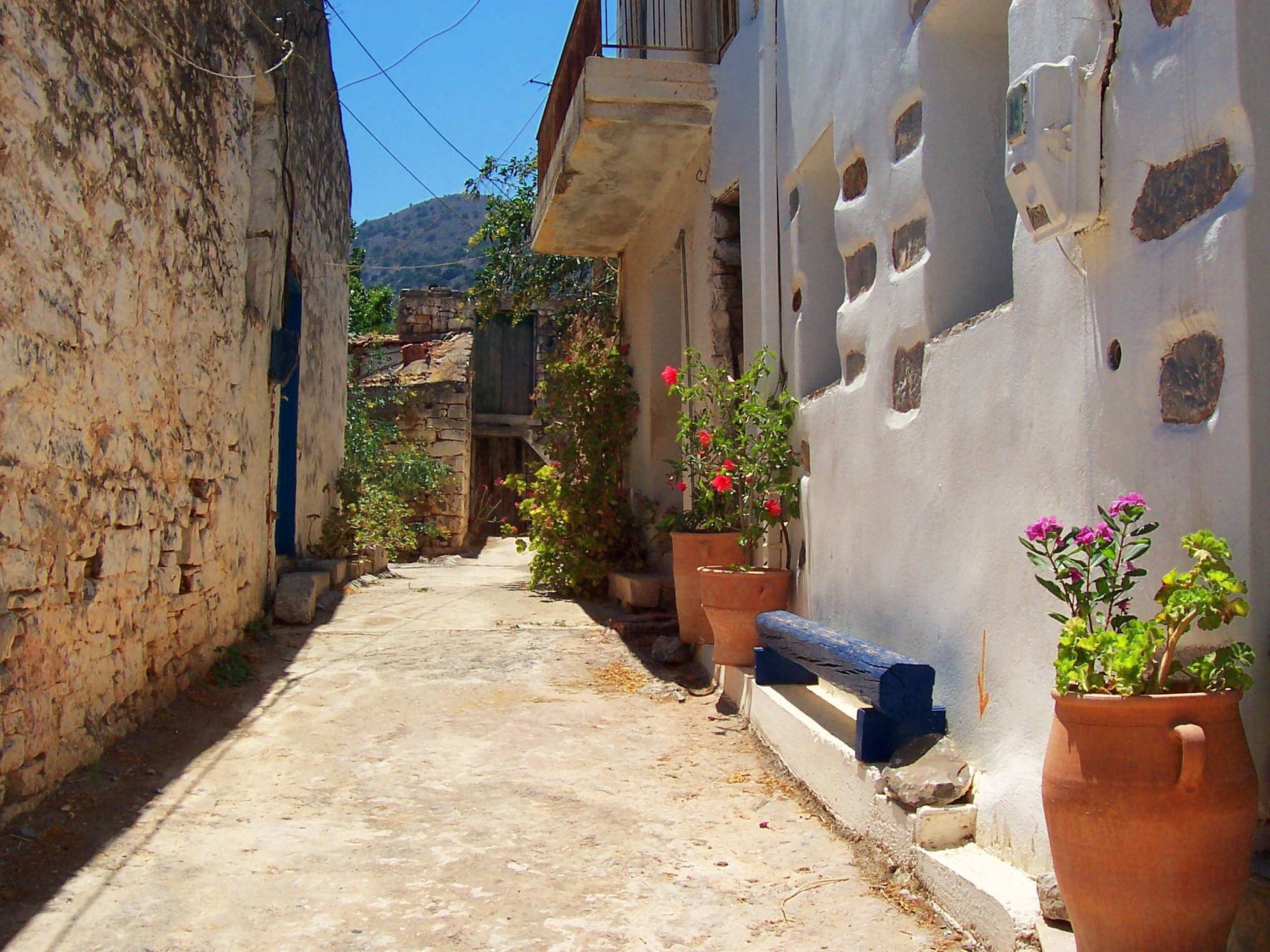
The E4 Hiking Trail Crete isn’t just about breathtaking views and rugged paths—it’s also packed with local secrets and off-the-beaten-path treasures that make the journey unforgettable. So here's some things to keep an eye out for.
- As you trek along the E4, you’ll pass
through charming villages where time seems to stand still. Stop for a
coffee in Anogeia, famous for its rich history and warm hospitality, or
take a detour to Aradena, a nearly abandoned village with a stunning
gorge.
- Some of the most scenic routes on the Crete E4
path hug the coastline, leading to hidden beaches like Sweetwater Beach
near Loutro. It’s a perfect spot to cool off and relax before hitting
the trail again.
- Beyond the famous landmarks, the trail is dotted with lesser-known historical sites such as small chapels, ancient ruins, and mysterious caves. Don’t miss the Cave of Agia Sofia near Kapsodasos, where history and mythology meet.
Local Tips for the Best Experience
- Chat with locals! They’ll often share secret spots or shortcuts.
- Try the local dishes in trail-side tavernas—nothing beats a fresh dakos or homemade cheese pie after a long hike.
- If you’re planning a hike on the E4 trail Crete, check for seasonal advice from villagers who know the terrain best.
Whether it’s a hidden cove or a welcoming village, these gems make the E4 Hiking Trail Crete much more than just a walk—it’s a way to connect with the heart of the island.
So, what are you waiting for? Lace up your boots and start exploring the unforgettable E4 trail.
Want to discover even more of what Crete has to offer?
Explore hidden gems, must-visit spots, and insider tips below!
Just Some of the Reasons We Love Crete
Did you love this page? Please share it with your friends!
© Copyright All Original Content 2006 - 2025 Completely-Crete.com. All
Rights Reserved. Reproduction in whole or in part without permission is
not permitted.
Click here to learn about developing your own money-generating website
from Solo Build It! - even with little or no web experience!
